🌀 Synoptic Dynamic Meteorology Monograph
A rigorous mathematical and dynamic treatise on mid-latitude synoptic weather systems. We evaluate the Norwegian Cyclone Model, the Shapiro-Keyser lifecycle, quasi-geostrophic (QG) omega and height tendency equations, baroclinic wave growth, conveyor belts, and bomb cyclogenesis.
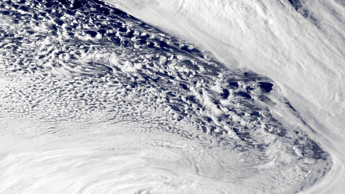
Extratropical cyclones represent the primary dynamical engines driving day-to-day weather variability across Earth’s temperate and sub-polar latitudes. Spanning horizontal spatial dimensions from 1,000 to over 3,000 kilometers, these massive low-pressure systems are responsible for widespread gale-force winds, extensive frontal cloud shields, heavy synoptic precipitation, and mid-latitude blizzards. In classical dynamic meteorology, an extratropical cyclone is understood as a fundamental thermodynamic mechanism through which the planet redistributes excess heat from the equatorial regions toward the polar heat sinks, converting available potential energy stored in horizontal temperature gradients into eddy kinetic energy.
The scientific conceptualization of mid-latitude storm systems was revolutionized during the First World War by the Bergen School of Meteorology in Norway, led by Vilhelm Bjerknes, Jacob Bjerknes, and Halvor Solberg. Cut off from international weather data, the Norwegian meteorologists established a dense network of surface observation stations across western Scandinavia. By analyzing fine-scale surface discontinuities in wind, temperature, and pressure, they formulated the celebrated Norwegian Cyclone Model (NCM), introducing military terminology—specifically the concept of atmospheric ‘fronts’—to describe the sharp battle lines separating distinct polar and tropical air masses.
1. The Classical Norwegian Cyclone Model: The Five Evolutionary Stages
The classical Norwegian model delineates the lifecycle of an extratropical cyclone through five sequential morphological stages, each defined by distinct thermodynamic and kinematic characteristics:
| Lifecycle Stage | Synoptic Morphology | Frontal Geometry | Upper-Level Forcing | Precipitation & Wind Field |
|---|---|---|---|---|
| Stage 1: Stationary Front | Quiescent, non-divergent boundary | Straight polar front separating cold polar and warm tropical air | Zonal, unperturbed upper-tropospheric jet flow | Light fog or drizzle; minimal pressure gradient |
| Stage 2: Wave Inception | Incipient frontal wave developing | Cyclonic kinking of polar front forming distinct warm and cold segments | Upper-level shortwave trough approaches from west | Pressure begins to fall at the wave apex; localized rain begins |
| Stage 3: Open Warm Sector | Mature, expanding baroclinic wave | Well-defined warm front ahead and trailing cold front behind low center | Divergence aloft ahead of upper trough axis | Expansive stratiform rain ahead of warm front; convective squalls along cold front |
| Stage 4: Occlusion Onset | Cold front overtakes warm front | Warm air lifted aloft, forming an occluded front (TROWAL) | Upper low stacks vertically above surface cyclone | Peak intensity; maximum central pressure deficit; widespread gale-force winds |
| Stage 5: Frontolysis / Decay | Cold-core barotropic vortex | Fronts decouple; warm air trapped entirely in mid-troposphere | Upper trough completely cuts off from jet stream (cutoff low) | Cyclone fills and weakens via surface boundary-layer friction |
2. Mathematical Foundations: Quasi-Geostrophic Theory and Baroclinic Instability
While the Norwegian model provided an intuitive surface framework, the rigorous three-dimensional fluid physics explaining why frontal waves grow was formulated decades later by Jule Charney (1947) and Eric Eady (1949) through the theory of baroclinic instability, mathematically formalized via Quasi-Geostrophic (QG) Theory.
In mid-latitudes, the atmosphere is in approximate geostrophic balance (balance between horizontal pressure gradient force and Coriolis force) and hydrostatic balance (balance between vertical pressure gradient and gravity). When geostrophic winds flow parallel to horizontal temperature gradients, thermal wind balance dictates that the horizontal wind speed must increase rapidly with height, creating the mid-latitude jet stream. An atmosphere characterized by strong horizontal temperature gradients (and therefore strong vertical wind shear) is defined as baroclinic.
In a baroclinic atmosphere, immense quantities of Available Potential Energy (APE) are stored within the sloping isentropic (constant potential temperature) surfaces. Charney and Eady proved that small-amplitude wave perturbations with wavelengths between 3,000 and 5,000 kilometers are dynamically unstable: they extract APE from the mean thermal gradient and convert it into eddy kinetic energy. The maximum growth rate of a baroclinic wave in the Eady model is given by:
sigma_max = 0.3098 * [ (f / N) * (du / dz) ]
where f is the Coriolis parameter, N is the Brunt-Väisälä buoyancy frequency (measuring static stability), and du/dz is the vertical shear of the zonal wind. This equation demonstrates that baroclinic wave growth accelerates under three conditions: strong Coriolis deflection, low static stability, and intense vertical wind shear.
The Quasi-Geostrophic Omega Equation
The primary diagnostic tool used by synoptic dynamicists to predict large-scale vertical air motion (and therefore cloud and storm formation) is the QG Omega Equation, written in pressure coordinates as:
(grad² + (f_o² / sigma) * (d² / dp²)) * omega = – [ (f_o / sigma) * (d / dp) [ – V_g · grad(zeta_g + f) ] ] – [ (R / (sigma * p)) * grad² [ – V_g · grad(T) ] ]
where omega is the vertical velocity in pressure coordinates (omega = dp/dt, where negative omega indicates upward vertical motion). This formidable equation isolates two primary dynamic forcing mechanisms:
- Differential Vorticity Advection (Term 1): When cyclonic vorticity advection increases with altitude (e.g., downstream of an upper-level trough where fast jet winds advect high cyclonic vorticity), the term forces strong upward vertical motion (omega < 0).
- Thermal Advection Laplacians (Term 2): Strong warm-air advection (WAA) produces positive Laplacian forcing, driving large-scale isentropic upglide and creating the expansive stratiform rain shield ahead of the surface warm front. Conversely, cold-air advection (CAA) behind the cold front drives downward vertical motion (subsidence), producing clear, post-frontal skies.
3. Modern Paradigms: The Shapiro-Keyser Model and Marine Cyclones
During the 1980s and 1990s, intensive aircraft and oceanic satellite observations of intense maritime cyclones—such as the devastating Fastnet Race Storm of 1979 and the Burns’ Day Storm of 1990—revealed that marine cyclones often deviate dramatically from the classic Norwegian model. In response, M.A. Shapiro and Daniel Keyser formulated the Shapiro-Keyser Cyclone Model, specifically tailored for cyclones developing over warm ocean currents with strong horizontal shear.
The Shapiro-Keyser model is characterized by four distinct structural divergences:
- Frontal T-Bone Architecture: Instead of the cold front advancing continuously until it collides with the warm front, the cold front fractures near the cyclone center. The warm front extends westward as a bent-back front, forming a distinctive perpendicular ‘T-bone’ intersection with the cold front.
- Warm Seclusion: As the cyclone reaches maximum maturity, the bent-back front encircles the low-pressure center, trapping a localized pool of warm, pristine maritime air within the storm core—a warm seclusion. This warm seclusion creates a cloud-free eye-like center surrounded by hurricane-force winds, mimicking the structural appearance of a tropical cyclone despite operating via extratropical baroclinic dynamics.
- The Sting Jet: In intense Shapiro-Keyser cyclones, an extremely narrow, descending jet of hurricane-force winds—termed a sting jet—erupts from the tip of the hooked cloud head. Driven by evaporative cooling of snow and conditional symmetric instability (CSI), the sting jet plunges to the ocean surface over a corridor less than 50 kilometers wide, generating localized gusts exceeding 160 km/h (100 mph) that inflict catastrophic maritime and coastal damage.
✈️ Conveyor Belt Theory in Extratropical Cyclones
Modern synoptic meteorology visualizes extratropical storms through three continuous 3D airstreams: the Warm Conveyor Belt (WCB) which originates in the warm sector and ascends poleward ahead of the cold front producing the main precipitation shield; the Cold Conveyor Belt (CCB) which flows westward beneath the WCB wrapping around the low center to form the comma head; and the Dry Slot (Dry Intrusion) which descends from the lower stratosphere behind the cold front, bringing dry, clear air into the heart of the storm.
4. Bomb Cyclogenesis: Explosive Maritime Deepening Dynamics
When an extratropical cyclone undergoes exceptionally rapid intensification, it is designated an explosive cyclogenesis event, colloquially termed a ‘meteorological bomb’. First quantified scientifically by Frederick Sanders and John Gyakum in 1980, a cyclone earns ‘bomb’ status when its central barometric pressure falls at a rate of at least 1 Bergeron (defined as a pressure drop of 24 hectopascals in 24 hours, normalized to latitude 60 degrees):
Rate (Bergerons) = [ (Delta-P / 24 hours) ] * [ sin(60°) / sin(phi) ]
Explosive cyclogenesis occurs primarily during winter over oceanic western boundary currents—specifically the Gulf Stream in the western North Atlantic and the Kuroshio Current in the western North Pacific. Here, frigid continental arctic air pouring off North America or Siberia meets warm tropical ocean water, establishing astronomical horizontal baroclinic temperature gradients. When an intense upper-tropospheric jet streak (wind speeds > 80 m/s) and a dynamic tropopause fold inject high potential vorticity (PV) air from the stratosphere directly over this surface baroclinic zone, the surface low detonates: central pressures can plummet by 40 to 60 hPa within 24 hours, producing ferocious nor’easters with barometric pressures comparable to major category 3 hurricanes.
The role of latent heat release during explosive maritime cyclogenesis cannot be overstated. As the warm conveyor belt ingests boundary-layer moisture evaporating off the Gulf Stream or Kuroshio, deep moist ascent triggers massive condensation. The release of latent heat in the mid-troposphere generates a powerful diabatic potential vorticity anomaly below the level of maximum heating. This diabatic PV anomaly acts in concert with the upper-tropospheric PV anomaly from the tropopause fold, establishing a mutually reinforcing vortex feedback that accelerates surface pressure falls far beyond what adiabatic baroclinic theory alone would predict.
5. Frontogenesis and Ageostrophic Transverse Circulations: The Sawyer-Eliassen Equation
In synoptic dynamics, fronts are not static geometric boundaries; they are active, evolving zones where horizontal temperature gradients are continually sharpened by kinematic wind deformation. The mathematical rate of change of the horizontal temperature gradient following fluid parcel motion is defined as the Petterssen Frontogenesis Function (F):
F = d / dt [ |grad(theta)| ] = (1 / 2) * |grad(theta)| * [ D_def * cos(2 * beta) – D_div ]
where D_def is total horizontal deformation, D_div is horizontal divergence, and beta is the angle between the isentropes and the axis of dilatation. When winds converge and stretch an existing temperature boundary, frontogenesis is positive, compressing the temperature gradient into a razor-sharp frontal zone measuring just tens of kilometers across.
To maintain thermal wind balance as the horizontal temperature gradient intensifies, the atmosphere must generate an ageostrophic transverse secondary circulation across the frontal plane, governed by the Sawyer-Eliassen Equation. This ageostrophic circulation forces warm air to accelerate upward along the sloping isentropic surface while forcing cold air to plunge downward beneath it. This dynamic cross-frontal circulation generates the narrow cold-frontal rainbands and intense convective squall lines routinely observed along advancing cold fronts.
6. Dynamic Tropopause Folds and Potential Vorticity Infiltration
A crowning achievement of modern synoptic dynamics is the integration of Potential Vorticity (PV) thinking, pioneered by Brian Hoskins and Raymond Hide. Ertel’s potential vorticity is defined as:
PV = (1 / rho) * (omega_a · grad(theta))
Because static stability d(theta)/dz is vastly higher in the stratosphere than in the troposphere, stratospheric air is distinguished by extreme values of potential vorticity (exceeding 2 PV Units / PVU, where 1 PVU = 10^-6 m²·s⁻¹·K·kg⁻¹). The boundary separating tropospheric low-PV air from stratospheric high-PV air defines the Dynamic Tropopause.
During intense cyclogenesis, the ageostrophic transverse circulation around a jet streak pulls the dynamic tropopause downward in a steep wedge—a tropopause fold—injecting high-PV, ozone-rich, dry stratospheric air deep into the mid-troposphere (down to 700 hPa). As this stratospheric high-PV anomaly overrides the surface warm front, it induces a cyclonic circulation that couples with the surface baroclinic vortex. Through this mutual amplification (the Hoskins-Bretherton-Castellano mechanism), the surface low deepens exponentially, cementing the cyclone’s status as a premier planetary heat-transport engine.
7. Downstream Development and Rossby Wave Packet Propagation
Extratropical cyclogenesis rarely occurs in total isolation. In synoptic-scale meteorology, individual cyclones are recognized as local manifestations of propagating Rossby wave packets that traverse entire ocean basins along the planetary storm track. When an intense cyclone deepens over the western North Pacific, the immense conversion of baroclinic potential energy generates a localized pulse of eddy kinetic energy.
This eddy energy disperses downstream at the group velocity of the Rossby wave packet, which typically travels at twice the phase speed of individual surface troughs. As the wave packet reaches the Gulf of Alaska, it excites a secondary downstream trough; within days, this downstream amplification triggers another cyclogenesis event over North America, which in turn radiates energy across the North Atlantic toward Europe. Understanding this process of downstream development allows modern operational meteorologists to anticipate extreme storm outbreaks across downstream continents more than seven to ten days in advance, illustrating the deeply interconnected hydrodynamic nature of Earth’s atmosphere.